Nevada King Commences Drilling at 100% Owned Atlanta Gold Mine, Nevada
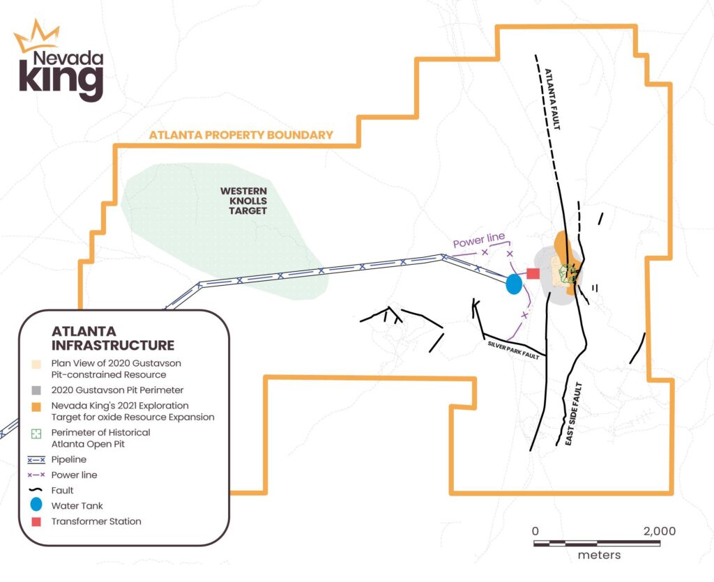
VANCOUVER, BC, June 22, 2021 – Nevada King Gold Corp. (TSX-V: NKG) (“Nevada King” or the “Company”) is pleased to to announce it has commenced a 4,200 meter, reverse circulation (“RC”) drilling program at its 5,166 hectare, 100% owned Atlanta Gold Mine Project (Figure 1), located 264km northeast of Las Vegas, in the prolific Battle Mountain Trend, Nevada.
Highlights
- The Atlanta Gold Mine historically produced 110,000 oz Au and 800,000 oz Ag. A recently published National Instrument 43-101 (“NI 43-101”) resource estimate by Gustavson Associates in 2020 (the “Gustavson 2020 Resource”) shows a pit constrained, measured and indicated mineral resource of 11M tonnes grading 1.3 g/t Au and 11.9 g/t Ag using a 0.35 g/t Au cut off, containing 460,000 oz Au and 4,220,000 oz Ag plus an inferred mineral resource of 5.31M tonnes grading 0.83 g/t Au and 7.3 g/t Ag, containing 142,000 oz Au and 1,240,000 oz Ag.
- The first stage of Nevada King’s 2021 drilling program consists of 52 RC holes averaging 80m in depth for a total of 4,200m (see Figure 2). Drilling commenced with one rig on June 19, 2021, while a second drill rig is en route and set to start turning in early July.
- This initial program is focused on resource expansion along the eastern portion of the historic Atlanta Open Pit where low historical drill density excluded potential large parts of shallower oxide mineralization occurring up-dip of the Gustavson 2020 Resource zone.
- The primary objective of initial drilling is to (1) confirm results from historical RC and core holes located along the eastern margin of the Gustavson 2020 Resource, (2) expand the 2020 resource northward, eastward, and southward into areas of sparse to non-existent historical drilling, and (3) expand upon the high-grade core mineralization seen in deeper historical holes along the eastern side of the Gustavon 2020 Resource zone.
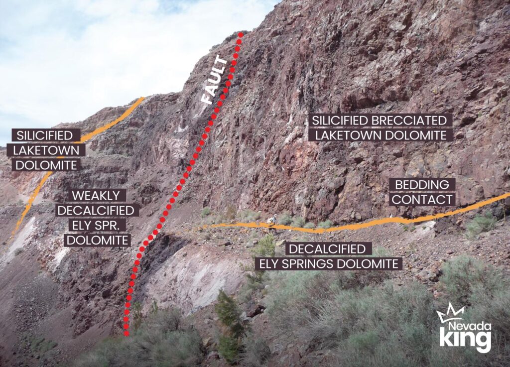
- High-grade core mineraltion that remains open for expansion has been intersected in previous drilling with results including: 32m grading 7.84 g/t Au in RC drill hole KR97-15 starting at 154m and 24m grading 4.56 g/t Au in RC drill hole ARC-02 starting at 158m.
- In a new structural interpretation for the Atlanta deposit, potential higher-grade gold mineralization will be targeted in drilling where high-angle shears intersect with the East Side Fault outside of the Atlanta pit.
- Reconnaissance drilling outside of the Atlanta pit area will test geophysical and geochemical anomalies elsewhere within under-explored portions of the 52km2 (5,166 hectares) property, looking for new gold targets as well as expanding known targets identified by historical drilling and surface sampling. These targets are still being identified through analysis of recently conducted surveys.
Cal Herron, Chief Operating Officer of Nevada King, stated, “Nevada King originally purchased the Atlanta Project in 2019 because we saw good potential for quickly expanding the existing NI 43-101 qualified resource and for discovering additional gold deposits within the large land package. Traditional structural interpretations explaining the distribution of gold mineralization within the Atlanta pit area focused historical drilling on the Atlanta Fault and vein zone, which meant exploratory drilling east of the Atlanta Fault and within the ‘barren dolomite footwall’ was very limited, and this prejudice is reflected in Gustavson’s 2020 Resource estimate. Nevada King’s recent geologic mapping and sampling within and around the existing pit generated an alternate structural interpretation positing a moderately westward dipping, mineralizing fault that crops out on the high ridge east of the pit and underlies the entire deposit. If this new structural concept is correct, we will be able to incorporate the shallow, widely scattered historical drill intercepts along the eastern side of deposit into the current resource model. Nevada King’s first stage drilling program is designed to test this hypothesis, and if successful, will substantially expand the measured and indicated resource and effectively convert much of the current waste rock to resource, thereby decreasing the strip ratio. This will in turn allow for a deeper pit, which will then incorporate more of the deeper, high-grade material previously defined by historical RC and core drilling.
At the same time, recent addition of detailed ground gravity, drone magnetic, and soil sample data infills large gaps in the historical database and now allows us to evaluate the property’s district-scale gold potential. Pre-1930s mining and prospecting activity together with widely scattered historical drill data suggest potential for additional silica breccia-hosted gold similar to the Atlanta Mine as well as gold mineralization occurring along Paleozoic basement – Tertiary volcanic contacts similar to Liberty Gold’s Goldstrike deposit in Utah. Much of the Atlanta District is obscured by alluvium and post-mineral volcanics, so the Company will be pursuing both target types utilizing its new soil sample and geophysical data prior to drill tests.”
First Stage 2021 Resource Expansion Drilling
The hole pattern for this initial RC drilling program starts along the northern, eastern, and southern margins of the current Gustavson 2020 Resource and is designed to expand the shallow oxide mineralization in three directions. Nevada King’s drill program consists of 52 RC holes totaling 4,200m and averaging 80m in depth per hole. Most of these holes are vertical, but angle holes will be utilized to reach into the historical pit to test exposed mineralization where pit benches are no longer accessible. Harris Exploration Drilling will be using a buggy-mounted Foremost Explorer 1500 and a track-mounted Schramm T685H, both operating with center-return hammers. Project supervision and support will be provided by the Company’s in-house geological and geotechnical staff. The existing dormitory, power, water, phone/internet, and RV hookups at Atlanta can accommodate both geological and drill crews, thereby eliminating long daily commutes from Ely or Pioche, NV.
Nevada King’s exploration concept is illustrated below in Figure 2 where the light orange-filled elongated body in the center of the figure represents the horizontal plan view of the Gustavson 2020 Resource, which is centrally located within the 2020 pit perimeter (about 840m diameter) as denoted by the hatched lighter gray line. Nevada King’s resource expansion target shown by the darker orange fill pattern wraps around the 2020 resource zone on three sides.
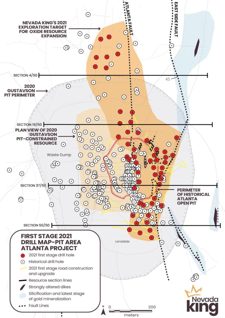
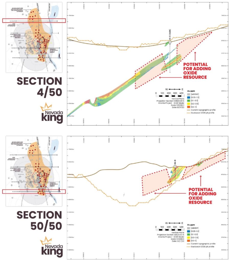
The “blank” areas within the historical drilling and within Gustavson’s 2020 resource model are evident in the four Gustavson drill sections shown in Figures 3 and 4, where the orange dotted line denotes the bottom profile of the 2020 pit-constrained resource model. Section 4/50 is 175m north of the Gustavson resource, and although historical drilling has shown mineralization to be present, the drill hole density was insufficient for inclusion within the resource model. This holds true for all drill sections located north of the northern edge of the 2020 resource zone. Nevada King’s 2021 drill program steps off in all four directions from the lone Meadow Bay RC hole RI-11-04RC along Section 4/50 in order to join with surrounding historical holes and bring this historically identified but currently un-classified mineralization into the resource category. In like manner, Nevada King’s 2021 drilling steps off in all directions from the lone historical hole on Section 50/50, thereby tying into the 2020 resource and tracking the mineralization southward into previously untested ground.
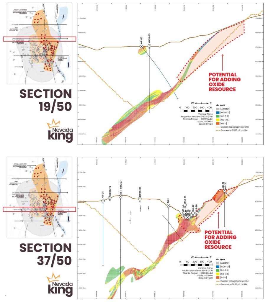
The two Gustavson drill sections shown in Figure 4 characterize much of the 2020 resource zone, where low historical drill density from the center of the historical Atlanta pit to the eastern side of the pit did not allow for inclusion of pre-1989 drill intercepts and mineralization exposed along the pit walls into the 2020 resource calculation. These earlier drill holes were assayed at the mine’s onsite laboratory and the detection limits were high, so the assay quality was deemed to be sub-standard for NI 43-101 reporting. Uncertainty regarding collar elevations for these holes also figured into Gustavson’s decision to exclude them. For example, Bobcat Properties Inc. drilled vertical RC hole 88-09 in 1988 and cut 24.4m (true mineralized thickness unknown) grading 11.77g/t Au at 128m-178.4m, including 4.6m at 166.2m-173.8m grading 45.54g/t Au. This Bobcat hole is located along the eastern margin of the Gustavson 2020 resource zone but was not included in the resource calculation, nor were many shallower oxide intercepts drilled east of 88-09 closer to the center of the historical pit. Nevada King’s 2021 program in part seeks to confirm a number of these historical holes, and as seen in Section 37/50 this historical data can be used as a guide for our 2021 drilling program, tagging onto the eastern side of the 2020 resource zone and moving the mineralization downward, eastward, and up-dip.
Tracking Shallow High-Grade Mineralization
Expanding the current gold resource is certainly the primary objective of this first stage drilling program, but Nevada King also sees good potential for expanding the high-grade core mineralization seen in deeper holes along the eastern side of the Gustavson resource zone. It is known from early drill holes that were not included in the 2020 resource calculation that high grades are present close to the bottom of the historical Atlanta pit. An example of this is RC hole A-86-06, drilled in 1986 after the mining activity ceased, and reportedly hitting 20m in a vertical hole grading 5.69 g/t starting at 4.5m depth and ending at 24m in 6.38g/t. Hole A86-6 is located 40m south of Section 37/50 (Fig. 4) at the SW corner of the old pit and is shown in Gustavson’s (2020) drill section 39/50, but the hole intercept was not used in the resource calculation. The Company therefore seeks to confirm these shallow high grade historical drill intercepts and incorporate them into the resource zone.
Referring again to Section 37/50, the depicted high grade mineralization seen at the bottom of the historical pit is not included within the 2020 resource calculation, while the top of the 2020 resource zone starts 50m below the bottom of the pit with a long high-grade intercept in Kinross RC hole KR97-15 (angled eastward at -45o) that returned a 32m down-hole intercept starting at 154m down-hole depth grading 7.84g/t Au, including 7.6m grading 12.28g/t Au. Other westward directed angle holes in the immediate vicinity of KR97-15 hit the same mineralized zone but somewhat deeper down (Table 1).
A number of holes within Nevada King’s 2021 drilling program will therefore be dedicated to connecting the deeper high grade mineralization seen in the Kinross and Goldfield holes with the shallow (but NI 43-101 non-compliant) high grade hits seen in the 1981 through 1989 drilling.
Advancing the Atlanta Geologic Model
Nevada King’s Atlanta field crew has been conducting geologic mapping and rock chip sampling within and around the historical Atlanta pit since March 2021. In historical property reports, the Atlanta deposit is generally described as a mineralized silica breccia zone that was localized along the northerly trending Atlanta Fault (Figure 2) that forms the contact between massive Ely Springs Dolomite on the east from strongly altered quartz monzonite and overlying unaltered Tertiary volcanics and sediments on the west.
Mining in the Atlanta pit ceased in 1985 due to falling gold price and rapidly increasing strip ratio, particularly on the east (Ely Springs Dolomite) and south (Eureka Quartzite) where steep slopes precluded mining grades averaging 2.5 g/t recoverable, or about 3 g/t head grade. Very little attention was given to the east side of the Atlanta Fault, as it was generally believed that there was very limited potential for finding additional mineralization, particularly at an average grade of 2 to 3 g/t. This prejudice followed the property up to the point of Nevada King’s involvement.
The Atlanta fault was presumed to be the main mineralizing feature, with a westward dip of about 45o. There are two problems with this interpretation:
- The Atlanta Fault runs down the middle of the historical open pit, and as seen in Section 37/50 (Figure 4) the west-dipping mineralized zone extends well eastward of the Atlanta Fault and up onto the steep slope east of the pit.
- Where observed in the pit, the mineralized portion of the Atlanta Fault is vertical to 80o west-dipping. Previous operators attributed this inconsistency with the 45o dip model to a listric-type fault that flattens rapidly westward. However, based on the drill sections, the fault would have to flatten 40o over 50m vertical length, which is highly unlikely.
The other historical presumption that there is no significant mineralization east of the Atlanta Fault is similarly flawed. The gold mineralization encountered in historical holes located well east of the Atlanta fault in Sections 37/50 (Figure 4) and 50/50 (Figure 3) say otherwise.
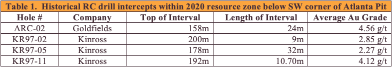
These inconsistencies were noted during Nevada King’s field examination last March. Nevada King accordingly started looking at the eastern side of the open pit and up on the steep slope further eastward, where the Company noted a variety of different structures, all of which accompanied gold mineralization in outcrop. A major NNE-striking, 45o west-dipping contact identified as the East Side Fault in Figure 2 was mapped along the southeastern rim of the pit and up onto the high ridge east of the pit. This silicified breccia zone hosts strongly silicified and argillized felsic tuff dikes and divides massive Ely Springs Dolomite on the east from variably silicified Ely Springs Dolomite and Laketown Dolomite on the west. Outcrop samples along this structure returned values up to 0.86ppm Au across 5m. The fault projects westward underneath the historic Atlanta pit and appears to form the lower contact of the 45o west-dipping main mineralized zone shown in all of the Gustavson drill sections. Nevada King therefore considers the East Side Fault to be the main control over gold distribution at Atlanta, not the Atlanta Fault, which is now viewed as a hanging wall splay. Indeed, several other vertical to steeply east dipping, northerly trending faults with altered tuff dikes chop up the Ely Springs Dolomite across the eastern half of the open pit area, dropping narrow wedges of strongly silicified Laketown Dolomite into variably decalcified blocks of massive Ely Springs (Figure 5). The felsic tuff dikes typically show evidence of volatile brecciation and adjacent Laketown Dolomite beds show evidence of collapsed brecciation and subsequent silica replacement (Figure 6).
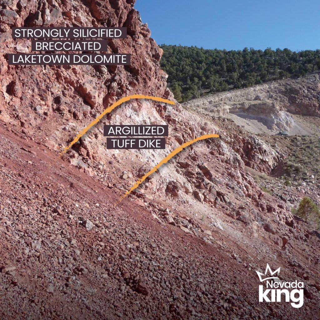
Sulfides are generally not present due to strong oxidation, but some densely silicified blocks contain 2%-3% fine grained disseminated pyrite. Contacts between the Laketown and Ely Springs units are characteristically marked by intensely silicified collapsed breccia in the Laketown beds and intense de-calcification in the adjacent Ely Springs that is accompanied by very strong manganese and iron oxides (Figure 5). The thin to medium-bedded Laketown Dolomite is completely silicified, whereas the alteration noted in the Ely Springs extends from 1m to 10m into the massive dolomite blocks that are generally devoid of obvious alteration. All along the eastern pit wall, bedding within this N-S sheeted shear and dike zone is strongly contorted, with isoclinal and recumbent folding in the more intensely altered zones. Very limited surface sample data collected throughout this altered zone indicates low grade gold in the silicified Laketown Dolomite, generally ranging between 0.30 to 1.20 g/t Au, while the variably decalcified dolomite typically runs in the 0.10 to 0.30 g/t range. A series of rock chip samples collected across a portion of this structure zone returned 1.11 g/t across 23m (true thickness), so the Company knows there are some wide zones of consistent mineralization. Nevada King is now in the process of systematically sampling the benches and outcrops (see NV King geologist in center of Figure 5) along the eastern half of the pit as well as the silicified outcrops extending up to 1km east of the pit. It should be noted that northerly-trending altered tuff dikes occur all along the steep slope and high ridge east of the pit, popping up through near-horizontal Ely Springs and Laketown Dolomite, producing local zones of silicification and anomalous gold mineralization.
Historical Background
Underground mining along the Atlanta Fault commenced in 1905 and small tonnages were intermittently mined via underground and open pit methods by numerous operators up through the 1960s. With rising gold prices in the 1970s, Standard Slag enlarged the Atlanta pit and mined 1.5M tonnes, recovering 110,000 ounces gold and 800,000 ounces silver between 1975 and 1985. Subsequent to 1985 explorers included Gold Fields Mining (1990-1991), Kinross Gold Corp (1997-1998), and Meadow Bay Gold (2011-2018), who collectively completed 58,800m of diamond drill and RC drilling. A significant amount of this core as well as drill pulps, RC rejects, and chip trays are preserved in an on-site storage facility.
Nevada King acquired the property from Meadow Bay Gold in 2019 and promptly staked an additional 255 lode claims around the core land position, bringing the total property up to 639 lode claims and 12 patented claims, covering 5166 hectares (Figure 1). Subsequent to acquisition the Company conducted a reconnaissance scale mapping and sampling program over areas of historical mining/prospecting and has since concluded district-scale soil sampling together with ground gravity and drone magnetic surveys. Soil sample results are still pending, while the geophysical data is currently being integrated with the surface geology preparatory to interpretive analysis and target generation.
Summary
In the new structural interpretation for the Atlanta deposit, the high-angle shears juxtaposing the Laketown and Ely Springs units are most likely hanging wall splays off of the basal East Side Fault, as is the mineralized Atlanta Fault. We would therefore expect to see higher gold grades occurring at the intersection of these hanging wall splays with the East Side Fault. Taking this structural model into the field, Nevada King will be drill-testing these potential intersection zones beneath and along the eastern side of the Atlanta pit and to the north and south of the 2020 resource zone in an effort to add more tonnage and decrease the strip ratio. Historical drill data, most of which was not included in the Gustavson 2020 resource model, strongly supports this structural interpretation, so now it is a matter of filling-in the gaps with the shallow 2021 drilling program and at the same time confirming the historical data, particularly the shallow high-grade intercepts.
This initial 2021 program will only serve to explain if this structural model is correct, and if successful, additional drilling will be necessary to move the target area shown in Figure 2 into the measured and indicated categories. At the same time, Nevada King’s surface mapping and sampling program, together with the recently completed ground gravity and drone magnetic data packages, will add better definition to exploration targets identified by historical exploration efforts in other parts of the Atlanta District (such as the large Western Knolls Target shown in Figure 1) and may reveal new targets for the Company to pursue, particularly in large areas throughout the project area that are covered by post-mineral volcanics and alluvium.
The project is accessible year round by maintained county roads and possesses a powerline connection to the local grid, an industrial well with water rights, and a full-service camp at site that can house up to fifteen people year-round. Exploration activities within the entire project area are permitted by an existing BLM Plan of Operation and Reclamation Bond.
Qualified Person
The scientific and technical information in this news release has been reviewed and approved by Calvin R. Herron, P.Geo., who is a Qualified Person as defined by NI 43-101.
About Nevada King Gold Corp.
Nevada King is the third largest mineral claim holder in the State of Nevada, behind Nevada Gold Mines (Barrick/Newmont) and Kinross Gold. Starting in 2016 the Company has staked large project areas in the Battle Mountain trend that are close to current or former producing gold mines, and that have significant historic exploration work. These project areas were initially selected based on their potential for hosting multi-million ounce gold deposits and were subsequently staked following a detailed geological evaluation. District-scale projects in Nevada King’s portfolio include (1) the 100% owned Atlanta Mine, located 100km southeast of Ely, (2) the Lewis and Horse Mountain-Mill Creek projects, both located between Nevada Gold Mines’ large Phoenix and Pipeline mines, and (3) the Iron Point vanadium and gold project, located 35km east of Winnemucca, Nevada.
The Atlanta Mine is a historical gold-silver producer with an NI 43-101 compliant pit-constrained resource of 460,000 oz Au in the measured and indicated category (11.0M tonnes at 1.3 g/t) plus an inferred resource of 142,000 oz Au (5.3M tonnes at 0.83 g/t). See the NI 43-101 Technical Report on Resources titled “Atlanta Property, Lincoln County, NV” with an effective date of October 6, 2020, and a report date of December 22, 2020, as prepared by Gustavson Associates and filed under the Company’s profile on SEDAR (www.sedar.com).
A drill program is currently underway at Atlanta aimed at expanding the existing resource as well as testing multiple targets elsewhere within the large Atlanta property package. The Lewis project exhibits significant gold mineralization at surface and in historic drilling and is adjacent to and on trend with Nevada Gold Mine’s Hilltop gold deposit (reported approximately 2M oz at 0.875 g/t Au). The Horse Mountain – Mill Creek Project is a lower plate target adjoining an active Nevada Gold Mines exploration project and hosts historic high-grade hits drilled by Barrick in carbonates beneath the Roberts Mountain Thrust. The Iron Point gold and vanadium project is located within a few kilometers of Interstate 80, 35km east of Winemucca, has high voltage electric power lines running through the project area and a railroad line passing across the northern property boundary. With $20M in working capital, Nevada King is well financed to advance further exploration of its gold projects as well as to advance the Iron Point Vanadium Project through resource estimation and initial feasibility study work. Nevada King has a proven capital market and mining team led by Executive Chairman Paul Matysek and CEO Collin Kettell.
Please see the Company’s website at www.nevadaking.ca.
For more information, contact Collin Kettell at collin@nevadaking.ca.
Cautionary Statements Regarding Forward Looking Information
Neither the TSX Venture Exchange nor its Regulation Services Provider (as that term is defined in the policies of the TSX Venture Exchange) accepts responsibility for the adequacy or accuracy of this release.
This news release contains certain “forward-looking information” and “forward-looking statements” (collectively “forward-looking statements”) within the meaning of applicable securities legislation. All statements, other than statements of historical fact, included herein, without limitation, statements relating the future operations and activities of Nevada King, are forward-looking statements. Forward-looking statements are frequently, but not always, identified by words such as “expects”, “anticipates”, “believes”, “intends”, “estimates”, “potential”, “possible”, and similar expressions, or statements that events, conditions, or results “will”, “may”, “could”, or” should” occur or be achieved. Forward-looking statements in this news release relate to, among other things, the Company’s exploration plans and the Company’s ability to potentially expand mineral resources and the impact thereon. There can be no assurance that such statements will prove to be accurate, and actual results and future events could differ materially from those anticipated in such statements. Forward-looking statements reflect the beliefs, opinions and projections on the date the statements are made and are based upon a number of assumptions and estimates that, while considered reasonable by Nevada King, are inherently subject to significant business, economic, competitive, political and social uncertainties and contingencies. Many factors, both known and unknown, could cause actual results, performance or achievements to be materially different from the results, performance or achievements that are or may be expressed or implied by such forward-looking statements and the parties have made assumptions and estimates based on or related to many of these factors. Such factors include, without limitation, the ability to complete proposed exploration work given the global COVID-19 pandemic, the results of exploration, continued availability of capital, and changes in general economic, market and business conditions. Readers should not place undue reliance on the forward-looking statements and information contained in this news release concerning these items. Nevada King does not assume any obligation to update the forward-looking statements of beliefs, opinions, projections, or other factors, should they change, except as required by applicable securities laws.